HGeo-TopoMap: Boosting Topological Mapping with Hierarchical Geometric Priors
July 23, 2026
Abstract
Topological maps are key outputs of autonomous driving perception systems, delivering essential road information for path planning. They identify instances such as centerlines and traffic signs, along with their connectivity relationships. Due to the lack of explicit markings for centerlines in real-world environments, the detection of centerline instances remains a significant challenge. To tackle this problem, we propose HGeo-TopoMap, which leverages an explicit prior map and implicit spatial relations to hierarchically boost topological mapping. First, a geometric adaptive learning module is designed for the road structure map obtained via inverse perspective mapping. This module discretely encodes semantic and spatial features from the map, followed by a prior-mask attention mechanism that selectively focuses on informative regions. Then, a geometric consistency learning module is devised, which leverages the geometric properties and spatial relationships of centerlines. Built on the geometry-aware decoder, it enforces spatial consistency by aligning features of centerline instances with identical geometric orientations. The proposed method is evaluated on the OpenLane-V2 dataset across the centerline, lane segment, and robustness benchmarks. Beyond substantial improvements in topological mapping accuracy, the proposed method offers the benefit of enhanced robustness, consistently outperforming baselines under both standard and challenging conditions. The source code and model weights will be made publicly available at https://github.com/lynn-yu/HGeo-TopoMap.
Topological Mapping, Geometry Priors, Semantic Segmentation, Autonomous Driving
1 Introduction↩︎
Online mapping has gained prominence in autonomous driving for its cost-effectiveness and adaptability to dynamic environments. Different map representations serve various downstream tasks [1], [2]. Rasterized maps characterize road space in grid form, often used for obstacle avoidance. Vectorized maps use points and lines to depict road geometry. Topological maps not only describe the structure and connectivity of road centerlines but also encode their relationships with traffic signs [3], which aligns closely with the requirements of path planning [4], [5].
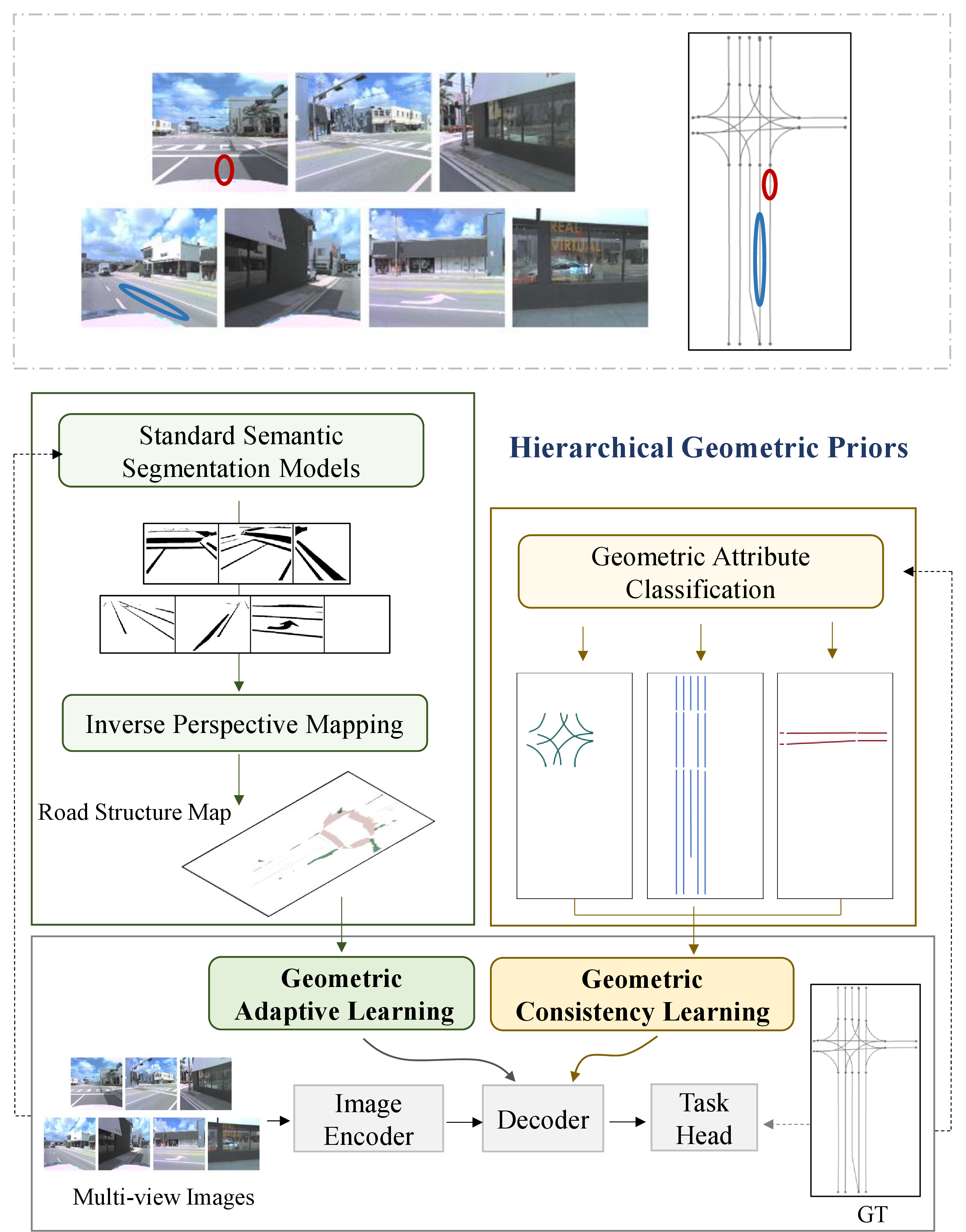
For better compatibility with downstream driving tasks, topological mapping is performed in the Bird’s Eye View (BEV), which involves detecting multiple classes of instances and inferring the topological relations among them [6], [7]. TopoNet [6] adopted a DETR architecture [8] for detecting traffic sign and centerline instances while embedding graph neural networks into centerline detection to learn topological relationships. Since connected centerlines share the same start and end points, TopoLogic [7] introduced the distances between start and end points of different centerline instances as a prior with the aim of enhancing topological relationship learning. LaneSegNet [9] identified a strong correlation between the lane boundary and the centerline, which introduced an auxiliary lane detection task, improving the accuracy of topological mapping. Notwithstanding the aforementioned progress, existing methods fail to address a critical issue inherent to centerline detection. In contrast to road boundaries and lane markings, centerlines are not visually distinctive in images, as depicted in the upper panel of Fig. 1. This lack of explicit visual cues frequently results in topological mapping performance degradation in complex and unconstrained surroundings of autonomous vehicles.
To address this issue, we explore whether leveraging the innate visual cues and intrinsic geometric relations inherent to centerlines can provide efficient guidance for instance modeling in topological mapping. Centerlines are typically situated between clear boundaries with clear structures. Moreover, current methods for perspective road map modeling [10], [11] have achieved remarkable performance. Although there exists a view discrepancy between the perspective road map and the BEV space of topological maps, an appropriate view transformer module can effectively bridge this gap. Inverse perspective mapping with assumed priors is an effective solution, offering an initial road structure map without requiring training [12]. However, factors like vehicle occlusion introduce noise into the road structure map, which naturally raises the need for an efficient prior learning module to effectively leverage this map. Then, it is observed that the global structure of centerlines in topological maps possesses well-defined geometric properties. As depicted in Fig. 1, centerlines can be categorized as either rectilinear or curvilinear, consistent with straight and turning road segments in real-world driving scenes. Regarding geometric configuration, rectilinear centerlines exhibit mutually parallel and perpendicular relationships. Such geometric information provides meaningful implicit priors. Explicit priors from road structure maps and implicit priors from the intrinsic geometry of centerlines are complementary in nature. Their joint exploitation provides a principled way to compensate for the missing visual features of the centerline.
Motivated by these observations, we propose HGeo-TopoMap to exploit these multi-level geometric priors comprehensively. First, a geometric adaptive learning module tailored to the road structure map derived from perspective road maps. It employs a discrete encoder for semantic-geometric feature extraction and a prior-masked attention mechanism for effective prior information selection. Then, a geometric consistency learning module is designed to implicitly align feature spaces by leveraging both the intrinsic geometric attributes of centerlines and their global geometric relationships. Extensive experiments under public centerline and lane segment benchmarks conducted on the OpenLane-V2 dataset [13] demonstrate that the proposed method effectively improves topological map quality. Furthermore, benefiting from geometric priors, the proposed method maintains competitive performance under robustness experiments.
In summary, our contributions are as follows:
We introduce a novel hierarchical geometric prior for boosting topological centerline mapping, which can be flexibly inserted at different benchmarks.
We leverage explicit road structure maps and the implicit geometric relationship as prior information, alleviating the issue of indistinct centerline features.
Experimental results under different topological mapping baselines validate that the proposed method exhibits consistent and significant improvements.
2 Related Work↩︎
2.1 Topological Mapping↩︎
Topological mapping is constructed in the Bird’s Eye View (BEV), rendering the view transformer from perspective views to the BEV a fundamental component. The view transformer module is typically achieved through either implicit or explicit learning methods. In map construction, explicit methods are more common [14]–[16].
In addition, it entails the detection of traffic sign and centerline instances, followed by learning the connectivity relationships between them. The detection of traffic signs commonly employs efficient backbones like Deformable DETR [17] and YOLO [18]. Normally, the detection process of centerline instances in topological mapping is highly similar to vectorized map tasks [19]–[21], employing a layer-wise regression learning approach. Subsequently, researchers observed that connected centerline instances share endpoints. To improve topological map accuracy, they separately explored point-level and line-level detection [22]–[26]. After detecting traffic signs and centerline instances, graph convolutional networks [6] and multi-layer perceptrons [27] are frequently employed as task heads to capture topological relationships between traffic signs and centerlines. These approaches perform topological reasoning on the basis of centerline instance detection, where topological accuracy hinges on detection performance. To enhance topology reasoning, RATopo [28] proposed a redundant assignment strategy that reorders the attention hierarchy, achieving a “one-to-many” assignment.
Simultaneously, several other approaches [29]–[33] exploited traffic knowledge to enhance topological learning performance. Chameleon [32] leveraged a vision-language model and traffic prompts to enhance map construction. TopoLogic [7] integrated geometric distances of centerlines into topology learning. However, these works rely solely on distance relations among centerlines as prior guidance, while overlooking other geometric spatial relationships such as parallelism and perpendicularity. To fully exploit these geometric relations, we introduce a consistency learning module for boosting topological mapping.

2.2 Priors for Topological Mapping↩︎
Generating maps from visual information faces the inherent sparsity problem of 2D data. Consequently, embedding various priors has become a crucial approach to enhancing map quality. Some works [34]–[42] employed High-Definition (HD) maps or standard definition maps as priors to compensate for the missing information in online map generation. Among these, some works directly interacted with HD map instances for learning, while others adopted generative methods to mitigate noise. Temporal cues provide valuable priors that mitigate the issue of sparse visual information [20], [43]. Moreover, D2HDMap [44] and AerialFusionMapNet [45] leveraged, respectively, driving paths and aerial images as auxiliary information to guide HD map construction. MGMap [46] and PercMap [47] empowered vectorized map decoding with perspective road semantics and geometry, boosting both generalization and accuracy. Similarly, Topo2D [48] also employed 2D road structure information to assist 3D lane line detection. Moreover, LaneSegNet [9] used road structure information in an auxiliary task to boost centerline detection accuracy. Nevertheless, these methods still require extra learning. Given the maturity of image-based road semantic segmentation, we argue that directly exploiting these priors is a more efficient and natural choice. Accordingly, this work leverages the perspective road map as input and proposes a geometric adaptive module for centerline detection.
3 Methodology↩︎
3.1 Problem Formulation↩︎
3.1.1 Perspective Road Maps↩︎
Map structures, such as dividers and pedestrian, are clearly observable in perspective images. The ease of road learning from perspective images is well matched by the maturity of existing semantic segmentation models. We adopt Mask2Former [10], which predicts class probabilities \(M_c \in \mathbb{R}^{Q{\times}C}\) and mask probabilities \(M_l \in \mathbb{R}^{Q{\times}H{\times}W}\). Aggregating them as \(S_m = M_c^{\top} M_l\) and taking the per-pixel \(\arg\max\) yields a one-hot perspective road map \(Map^p \in \{0,1\}^{C{\times}H{\times}W}\).
3.1.2 Inverse Perspective Mapping↩︎
Since topological maps are constructed in BEV whereas the perspective road map is defined in a different view, a view transformer is necessary. Inverse Perspective Mapping (IPM) is decoupled from model training, ensuring stable initial learning and generalization capability; it is therefore adopted as the view transformation strategy in this work. IPM assumes a flat road surface with zero ground elevation, allowing direct projection of perspective information into the BEV. Given multi-view perspective road maps \(Map_n^p\) with intrinsic \(T_{n}^{in}\) and extrinsic \(T_{n}^{ec}\) parameters, the BEV road structure map \(Map_{bev}\) is obtained through a hypothetical ground-plane height \(Z_0\): \[Map_{bev} = \sum_{n} \text{IPM}(Map_n^p,T_{n}^{in},T_{n}^{ec},Z_0),\] where the summation fuses overlapping camera views additively, accumulating per-class evidence across cameras.
3.2 Overview↩︎
Topological mapping encompasses the detection of traffic sign and centerline instances, view transformer, and topological relationship learning. In light of its efficiency and low computational cost, TopoLogic [7] is chosen as the baseline architecture for this work. The overview of the proposed HGeo-TopoMap is shown in Fig. 2.
Given multi-view images \(I_i\), multi-scale image features \(F_i\) are initially extracted through an image encoding backbone. The detection of traffic sign instances is performed by a dedicated task head implemented with Deformable DETR [17]. Concurrently, the image features are projected from the perspective view to BEV via BEVFormer [15]. The map instance decoder module extracts the centerline instance from the BEV features \(F_{bev}\), which employs a DETR architecture to perform decoding from instance queries \(Q_l\). Additionally, a graph convolutional network is integrated into the forward feedback network to capture the topological connections between centerline queries \(Q_l\) and traffic queries \(Q_t\). Finally, the multi-task heads predict the topology matrix, centerline categories, and centerline points, respectively.
Given the lack of distinctive visual cues for constructing maps, this work incorporates multi-level geometric priors to boost topologic mapping. Two complementary geometric learning components are designed to fully exploit these priors. A geometric adaptive learning module based on BEV road structure maps (introduced in Sec. 3.3) and a geometric consistency learning module with spatial prior relationships (described in Sec. 3.4).
3.3 Geometric Adaptive Learning↩︎
Road structure maps encode dividers and other road markings, which exhibit strong correlations with centerlines. Exploiting such correlations offers a viable means to compensate for the lack of explicit visual cues of centerlines. Starting from a perspective road map derived from conventional semantic segmentation, IPM can be applied to transform it into a BEV road structure map. Nevertheless, the resulting map is noisy: the segmentation suffers from boundary ambiguity and uncertainty [49], while the flat-ground assumption of IPM distorts distant and elevated regions [12]. To fully exploit the potential of priors, a geometric adaptive learning module is designed in this section.
Road structures encompass various categories, each exhibiting different spatial relationships with centerlines. For example, centerlines are positioned between lane dividers, while they are oriented perpendicular to stop lines. To this end, a multi-category encoder module is first designed to learn discriminative features for different road structure categories. For the road structure map, grids that belong to any semantic category are sampled to extract both occupancy states \(M_{o} \in \mathbb{R}^{N_o{\times}C}\) and spatial locations \(M_{p}\in \mathbb{R}^{N_o{\times}2}\), where \(N_o\) is the number of occupied grids. \[M_{o}, M_{p} = \text{Sample}(Map_{bev},Map_{bev}>0),\] where \(\mathrm{Sample}(\cdot,\cdot)\) gathers grid cells satisfying the condition. Then, semantic features \(Map_{emb}\) and positional features \(Map_{pos}\) are generated by a multi-category encoder \(MCE\) consisting of linear layers and a cosine-based positional encoder \(Sinpos\). \[M_{emb} = MCE(M_o),\] \[M_{pos} = Sinpos(M_{p}).\] Given that different road structures exhibit distinct geometric relationships with centerline instances, these relationships can further guide the learning of informative features. Then the spatial distance between centerline points \(P_I \in \mathbb{R}^{N_l{\times}N_p{\times}3}\) and occupied grids \(M_{p}\) serves as guidance, where \(N_l\) is the number of centerline instances and \(N_p\) denotes the number of vector points per instance. Specifically, the Euclidean distances (\(\text{EucDis}\)) between the 2D vector points \(P_I^{'}\) on each centerline instance and the occupied grid positions are computed to obtain a distance matrix. The final distance mask is generated by selecting, for each centerline instance, the distance to the nearest occupied grid: \[D_m = \text{Min}(\text{EucDis}(P_I^{'},M_{p}),dim=1) \in \mathbb{R}^{N_l{\times}N_o}.\] Finally, this distance mask is employed to guide the adaptive interaction between map instances and the road structure map through a prior-masked attention mechanism. The queries denote centerline instances \(Q_l\), with keys formed by \(Map_{emb} + Map_{pos}\). Thus, the attention mask is defined as \(-D_m/\text{k}\), where \(\text{k}\) represents a scaling factor.
3.4 Geometric Consistency Learning↩︎
The BEV road structure map serves as explicit geometric priors, but it should not be overlooked that topological maps themselves inherently possess geometric regularities. Centerlines in topological maps describe and represent vehicle trajectories, which are typically categorized as either straight or turning. This implies that different centerlines exhibit distinct geometric properties, i.e., rectilinear or curvilinear. Moreover, centerlines of adjacent lanes are evidently parallel, providing another geometric prior. This type of mutual geometric relation can serve as implicit guidance, complementing the explicit knowledge and together forming a synergistic relationship. To fully exploit the inherent geometric priors of topological maps for guiding learning, this section proposes a geometric consistency learning module.
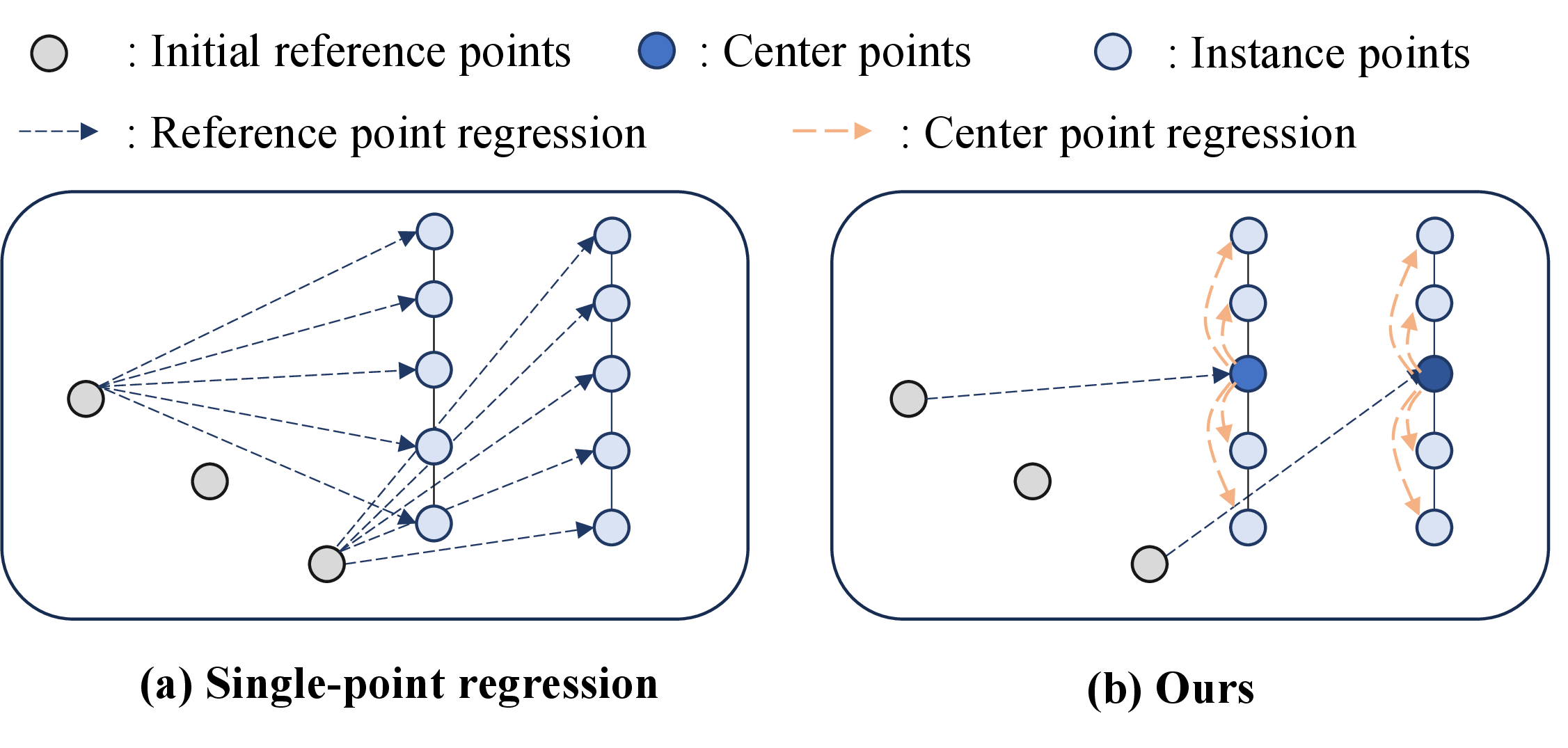
First, the centerline vector point regression is enhanced, which is equipped with the ability to capture geometric attributes. Unlike the unordered regression that predicts instance points from a single reference point [7], a stage-wise instance point regression strategy is devised to learn geometric attributes. In each decoding layer, the regression first learns from a single reference point to the instance center point. \[P_c = {CenRegHead}(Q_l)+P_{r},\] where \({CenRegHead}\) denotes the task head consisting of linear layers, normalization layers, and activation layers. \(P_{r}\) are the initial reference points in each layer. Meanwhile, an instance point head \({InsRegHead}\) is employed to learn geometric attributes based on center points with a structure similar to \({CenRegHead}\). \[P_I = {InsRegHead}(Q_l)+P_{c}.\] In addition, a geometry-aware attention mechanism is designed upon the standard cross-attention. Specifically, positional encodings of instance center points are embedded into the map instance queries to facilitate rapid geometry learning. \[Q_l^{i'} = Q_l^{i} + Sinpos(P_c),\] \[Q_l^{i+1} = {CrossAttn}(Q_l^{i'},F_{bev},P_{r}).\]
With this geometry-aware decoding module, each centerline instance is able to both regress instance points from the center point and acquire geometric attributes concurrently, as depicted in Fig. 3.
Then, the prior relationships among centerline instances are leveraged to guide consistent learning of instances. The improved decoder learns not only geometric properties but also spatial orientation derived from center point regression. As shown in Fig. 3 (b), parallel centerlines exhibit consistent spatial orientations derived from center point regression, indicating an implicit feature alignment between their instance queries. Inspired by this observation, a contrastive learning strategy harvesting geometric spatial relations is introduced to guide the detection of instances, enhancing the performance of topological mapping.
The module selects positive and negative samples based on geometric attributes, then enlarges feature distances for instances with distinct geometric properties or spatial orientations, while reducing distances for those sharing the same geometry and spatial relations. Specifically, centerline instances of a topological map are first classified into straight and curved groups, \(G_s\) and \(G_c\), based on their geometric curvature. In typical topological maps, straight centerlines can be broadly divided into two major groups, with a significant angular difference between their spatial orientations. Accordingly, within the straight group, they are further clustered into two subsets according to the slopes of their vector points, \(G_{l1}\) and \(G_{l2}\). \[G = \{ G_{l1}, \;G_{l2}, \;G_c \}. \] To guarantee that instance features of each geometric property are fully utilized for guidance, the contrastive learning scheme is concurrently applied to all groups. The anchor plays a central role in guiding the learning direction in contrastive learning. Thus, instance queries \(q_i\in Q_l\) that are correctly matched to the ground truth are designated as anchor ‘\(v\)’ within each subgroup. \[v = \{q_i|q_i \in G_i,\text{match}(q_i,\text{GT})=\text{True}\}. \] Positive samples \(S_{pos}\) are selected from other high-scoring instances within the same group, whereas low-scoring ones are discarded to prevent misleading guidance. Negative samples \(S_{neg}\) are drawn from other groups \(G_{other}\) with distinct geometric features, while low-scoring instances are likewise discarded. \[S_{pos} = \{q_j|q_j\in G_i,q_j!=v,e_j>t_s\}, \] \[S_{neg} = \{q_j|q_j\in G_{other},e_j>t_s\},\] The instance reliability threshold \(t_s\) follows the same criteria used in other works [6], [7] for selecting reliable instances. \(e_j\) is the score of each instance.
To extract spatial orientation features for each instance, a lightweight contrastive learning head consisting of multiple linear layers is applied for instance queries.
Finally, the InfoNCE loss is applied concurrently over all subgroups: \[L_{gcl}= -\sum_{G_i\in G}\sum_{v\in \mathcal{V}_i} \log \frac{\exp(z_v^{\top} z_{k^+})}{\Omega(v)},\] where \(\Omega(v)=\exp(z_v^{\top} z_{k^+})+\sum_{k^-\in\mathcal{N}(v)}\exp(z_v^{\top} z_{k^-})\) aggregates the positive and all negative pairs, and \(z_{k^+}\), \(z_{k^-}\) denote the projected embeddings of positive and negative samples, respectively.
3.5 Overall Loss↩︎
The standard topological mapping task involves three loss terms, namely traffic detection loss \(L_{det}\), centerline instance detection loss \(L_{l}\), and topology reasoning loss \(L_{topo}\), which are adopted similarly to TopoLogic and other existing methods. Based on this foundation, an instance center point loss \(L_c\): \[L_c = \text{L1}(P_c,GT_c),\] where \(GT_c\) is the center point of each centerline instance GT. Consequently, the complete loss function is given by the following equation. \[L = L_{det} + L_{l} + L_{topo}+\alpha *L_c+\beta *L_{gcl},\] where \(\alpha\) and \(\beta\) are the weights to balance the impact of the multi-level prior in the task of topological mapping.
4 Experiments↩︎
4.1 Datasets and Metrics↩︎
OpenLane-V2 [13] is a large-scale dataset established for topological reasoning in autonomous driving. The dataset offers diverse annotations, covering centerlines, traffic signs, inter-centerline topology, and centerline-traffic sign topology. Additionally, LaneSegNet [9] provides auxiliary lane annotations for each centerline. The proposed method is evaluated on the centerline and lane segment benchmark of this dataset.
OpenLane-V2 provides a standardized evaluation protocol for the centerline benchmark. The accuracy of centerline instances is measured by \(\text{DET}_l\), which is the average precision across different Fréchet distance thresholds. Traffic sign detection \(\text{DET}_t\) adopts Intersection over Union (IoU) as the similarity metric. \(\text{TOP}_{ll}\) and \(\text{TOP}_{lt}\) are used to evaluate the similarity of topology matrices among lanes and between lanes and traffic elements, respectively. Finally, the \(\text{OLS}\) metric is employed to measure overall topological map accuracy.
In the lane segment benchmark, it is evaluated using the same metrics as LaneSegNet. Average precision is adopted for both lane \(\text{AP}_{ls}\) and pedestrian \(\text{AP}_{ped}\) detection, while \(\text{TOP}_{lsls}\) is used for topological reasoning.
4.2 Implementation Details↩︎
The perceptual range for topological mapping is \(102.4{\times}51.2\) meters, corresponding to a BEV feature map of size \(200{\times}100\). The perspective road maps with a \(388{\times}512\) size are generated by Mask2Former, which is pre-trained on the Mapillary Vistas dataset [50]. The road structure map is produced by applying IPM to perspective road maps. To maintain fidelity of the view transformer, we constrain its effective range to \(60{\times}30\) meters. Additionally, \(k{=}0.1\) is defined in the GAL module. \(\alpha{=}1\) and \(\beta{=}0.1\) are set as the weights of the loss. All experiments are trained for \(24\) epochs on an NVIDIA RTX A6000 GPU with a batch size of \(4\). The optimizers for different tasks remain consistent with the respective baselines, and the learning rate is automatically scaled according to the batch size.
4.3 Comparison to State-of-the-art Methods↩︎
Comparison on the Centerline Benchmark of Topologic Mapping: This benchmark covers the detection of centerline and traffic sign, with two topology reasoning tasks. TopoLogic [7] is chosen as the baseline for its good accuracy-efficiency trade-off. The experimental results are presented in Table ¿tbl:tab:center95compare?. Compared with the baseline, the proposed hierarchical prior method improves the OLS metric by \(+2.0\%\). Specifically, the accuracy of centerline instance increases by \(+1.6\%\), which in turn brings a \(+1.2\%\) improvement in topological reasoning accuracy. These results demonstrate that hierarchical geometric priors can effectively guide centerline instance detection and alleviate the issue of missing visual cues.
Comparison on the Lane Segment Benchmark of Topologic Mapping: Beyond centerline instance detection, this benchmark includes auxiliary tasks for lane and pedestrian detection, as originally proposed by LaneSegNet [9]. Therefore, LaneSegNet is selected as the baseline in this section, with experimental results presented in Table ¿tbl:tab:lane95compare?. Evidently, the proposed method achieves superior performance in lane segmentation, reaching \(34.0\%\) mAP. Compared with the baseline, the proposed method improves by \(+5.7\%\) mAP. The boost largely comes from the prior road structure map, which provides rough pedestrian locations to guide instance decoding. Moreover, the inter-lane topology reasoning accuracy improves by \(+1.8\%\). These findings verify that hierarchical prior guidance not only boosts centerline instance detection performance but also strengthens topological relation reasoning.
![Figure 4: Qualitative comparison on two baselines of topologic mapping, TopoLogic [7] and LaneSegNet [9].](/article/2607.21281/figure/show_.png "fig:")
4.4 Ablation Studies↩︎
Core Modules: The ablation experiments are performed to assess the effectiveness of our proposed Geometric Adaptive Learning (GAL) module and Geometric Consistency Learning (GCL) module, respectively. Table ¿tbl:tab:core? reports that both GCL and GAL contribute positively to centerline instance detection, yielding improvements of \(+0.9\%\) and \(+0.7\%\), respectively. Correspondingly, the overall OLS metric also registers gains of \(+0.8\%\) and \(+1.2\%\). These findings clearly validate that the complementary nature of explicit and implicit priors significantly enhances the accuracy of topological mapping.
Weight of Geometric Consistency Learning Loss: The geometric consistency learning module adopts the consistent loss with a weight factor \(\alpha\) to constrain the learning of spatial relationships among centerline instances. This section investigates the impact of varying weight magnitudes to identify the optimal constraint intensity. Table ¿tbl:tab:lossweight? demonstrates that the optimal overall topological map accuracy is achieved with a weight value of \(0.01\). However, when the weight is set to \(0.1\), traffic sign accuracy slightly decreases, while instance detection accuracy remains comparable. In this case, topological reasoning achieves a more balanced performance.
Position of Geometric Adaptive Learning: The BEV road structure map is integrated into the iterative centerline instance decoding pipeline. We ablate its insertion position to determine where it best guides learning. Table ¿tbl:tab:position? reports results on two baselines, which show different trends. The lane segment baseline reports that embedding the map at the intermediate decoder layer yields optimal results, achieving a centerline detection accuracy of \(33.7\%\) mAP. But the centerline baseline performs best with early embedding. This discrepancy can be attributed to their different decoding paradigms. The former uses regression-based learning, where early features are unaligned. The latter directly predicts instances at each layer, making early injection more effective for spatial correction.
Analysis of Geometric Consistency Learning: The geometric consistency learning module consists of a geometry-aware decoder and a geometric contrastive learning component. In this section, we evaluate their individual effectiveness separately. Table ¿tbl:tab:center? reports that both components are effective, among which the geometric contrastive learning component yields a \(0.6\%\) gain in the OLS metric.
Prior Effect of Vectorized Mapping: To comprehensively assess the broad applicability of the BEV road structure map guidance mechanism, this section extends the evaluation to the vectorized map task. StreamMapNet [20] is selected as the baseline for this evaluation, with results reported in Table ¿tbl:tab:vecmap?. Evidently, given that the map contains divider and pedestrian classes that correspond to vectorized maps, integrating this prior yields a large boost of \(+14.5\%\) in map accuracy.
4.5 Visual Results↩︎
The visual results are shown in Fig. 4. The experimental results demonstrate that the proposed method achieves a more detailed mapping capability. Notably, it more accurately identifies centerline structures in complex scenarios such as multi-lane merges. This capability is of critical importance for the safe deployment of autonomous vehicles, as merging zones are known to be high-risk areas for collisions. Furthermore, the proposed method achieves a more precise reconstruction of road elements such as pedestrians, which can be attributed to the prior map guidance.

4.6 Robustness Analysis↩︎
Topological mapping relies on multi-view images, making map quality sensitive to input completeness. Sensor damage in real scenes often causes missing views, endangering vehicle safety. To comprehensively assess the robustness of the proposed method, this section further evaluates map construction performance under missing viewpoints. As shown in Fig. 5, experiments under various missing-view scenarios reveal that the absence of front-view cameras causes the most significant performance degradation. This finding is consistent with the inherent reliance of autonomous driving on forward perception. Nevertheless, the proposed method demonstrates significantly better robustness than the baseline. Notably, under the rear-left view missing setting, it achieves a \(7.5\%\) improvement in centerline detection accuracy. Both normal and missing-view experimental results consistently demonstrate that the proposed method is more applicable to real-world scenarios.
5 Conclusion↩︎
In this paper, a hierarchical prior module is introduced for boosting topological mapping. It facilitates topological mapping via geometric adaptive and geometric consistency learning, respectively. The effectiveness of the hierarchical prior module is verified on two benchmarks, where it consistently delivers substantial gains in map accuracy. Furthermore, in the robustness experiments, the proposed method maintains high performance.
While the road structure map derived from perspective views provides valuable prior guidance for BEV mapping, information deficiency persists in single-frame maps under complex scenarios. To address this, future work will explore temporal cues with optimization algorithms to generate optimal road structure maps.
References↩︎
This work was supported in part by the National Natural Science Foundation of China (Grant No. 62473139), in part by the Hunan Provincial Research and Development Project (Grant No. 2025QK3019), and in part by the State Key Laboratory of Autonomous Intelligent Unmanned Systems (the opening project number ZZKF2025-2-10).↩︎
\(^{1}\)The authors are with the School of Automation and Electrical Engineering, Zhejiang University of Science and Technology, China.↩︎
\(^{2}\)The authors are with the School of Artificial Intelligence and Robotics and the National Engineering Research Center of Robot Visual Perception and Control Technology, Hunan University, China (email: kailun.yang@hnu.edu.cn).↩︎
\(^{3}\)The authors are with the Institute for Anthropomatics and Robotics, Karlsruhe Institute of Technology, Germany.↩︎
\(^{\dagger}\)Corresponding authors: Kailun Yang and Kunyu Peng.↩︎